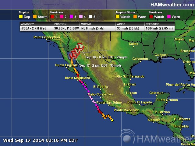
Odile Poised to Bring Catastrophic Flooding to Southwest US
By Alex Sosnowski
Odile will unload tremendous rainfall over a large part of the Southwest United States that will run off the mountains and into the desert valleys and plains through the end of the week.
While the rain will continue to ease the long-term drought in the region, too much rain will fall too quickly for the landscape to absorb.
AccuWeather.com Chief Operating Officer Evan Myers and Western Weather Expert Ken Clark discuss the heavy rainfall and flooding risk in detail below:
“There is the potential for devastating, catastrophic and historic flooding in this scenario,” Clark stated in an interview.
Heavy rainfall will hit southeastern Arizona and much of New Mexico, where a general 3 to 6 inches are forecast. However, local amounts of 10 inches or more are possible on the slopes of the mountains from southeast of Tucson, Arizona, to central New Mexico. Rainfall of 1 to 2 inches per hour can occur.
There is a significant risk to lives and property in the region.
“Not only will flash and urban flooding occur in this case, but there is the potential for major river flooding,” Clark said.
Since early Tuesday, nearly 2 inches of rain has fallen on Deming, New Mexico, with close to an inch at Truth or Consequences, New Mexico. Near Stafford, Arizona, 2.6 inches of rain fell in six hours early Wednesday morning. The amount of rain and rainfall rates will continue to ramp up in parts of the Southwest through Thursday.
This is the type of threat that can cause water to sweep through normally dry stream beds, called arroyos, and into villages, towns and major cities rapidly. Major roads can be damaged and some bridges along secondary roads could be swept away. Mudslides and dust storms can block roads in a few locations.
“Travel on Interstate-10 between El Paso, Texas, and Phoenix will be dangerous,” Clark said.
A safer route from the Plains to California will be I-40, but delays and poor visibility are possible due to heavy rain.
The rain from Odile is coming just one week after moisture from Norbert drenched the region, creating major flooding.
Some areas around Phoenix and Las Vegas are still cleaning up.
RELATED:
Major Hurricane Odile to Bring Life-Threatening Impacts to Baja California
Odile’s Heavy Rain, Flood Risk May Reach Central US
Interactive Radar
Norbert caused a daily record rainfall of 3.29 inches at Phoenix earlier in September.
The combined rainfall from Norbert and Odile has the potential to cause this September to be the wettest ever in some areas. For example, according to the National Weather Service, the record rainfall for September at Tucson is 5.60 inches, which was set in 2001. Thus far this month, about 2.7 inches of rain have fallen at Tucson.
Cities that could be affected by the heavy, flooding thunderstorms include Phoenix, Flagstaff, Tucson and Yuma, Arizona; Albuquerque, New Mexico; and El Paso, Texas.
Spotty, heavy thunderstorms can reach as far to the north and west as Las Vegas, Palm Springs, California, and Salt Lake City, Utah.
“The greatest risk of widespread flooding in the Southwest will be from early Wednesday morning into Thursday night,” Clark said.
“However, spotty heavy showers and thunderstorms will continue, especially over the higher terrain, into the weekend and can lead to additional flooding in isolated areas.”
Heavy rain and the threat of flooding will expand to the Plains late this week and continue into the weekend.
