Here Comes Soon-To-Be Hurricane Maria
Irma-battered Caribbean islands brace for Maria’s flooding, damaging winds
By Kristina Pydynowski, AccuWeather senior meteorologist
Budding Hurricane Maria poses a significant threat to Irma-devastated areas in the northern Caribbean early this week.
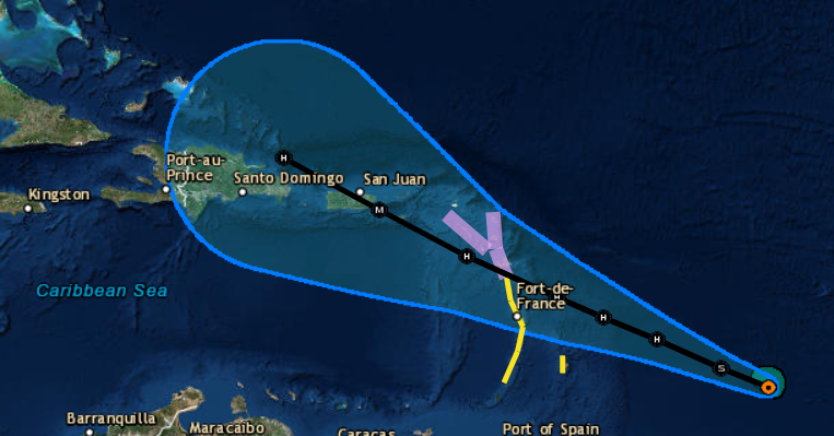
Tropical Storm Maria, located 450 miles east-southeast of the Lesser Antilles, continues to strengthen as it tracks west-northwestward. People in the Lesser Antilles should be preparing for yet another impactful tropical system.
Puerto Rico Gov. Ricardo Rossello tweeted that the government is working to finalize plans for Maria.
Nos acompaña Alejandro De La Campa @femaregion2 para ultimar detalles de la preparación gubernamental. #MariaPR pic.twitter.com/0PlGaJVw57
— Ricardo Rosselló (@ricardorossello) September 17, 2017
At a Saturday press conference, U.S. Virgin Islands Gov. Kenneth Mapp warned residents they should be prepared for Maria, the next storm to hit the islands after Irma.
Conditions are conducive for the storm to ramp up into a Category 2 hurricane prior to reaching the Lesser Antilles on Monday night and Tuesday.
This is the third tropical system to impact the area in two weeks, following major hurricanes Irma and Jose during the first week of September.

While it is unlikely that the storm will reach Irma’s intense strength by the time it approaches, the brisk pace of the storm means there is little time for preparations to be completed on the islands.
Seas will build along the east-facing beaches of the Leeward Islands as the strengthening storm approaches through Monday. Torrential rain and damaging winds will then increase on Monday night and into Tuesday.
Some of the islands that were largely spared from Irma’s wrath may take a direct hit from the storm, including Montserrat, Guadeloupe, Dominica and Martinique.
Residents should prepare for widespread tree damage, days to weeks of power outages and structural damage at the hands of a Category 2 hurricane. Well-constructed homes may sustain major roof or siding damage.
Due to the forecasted path of Hurricane Maria, we’ve issued a travel waiver. See more info here: https://t.co/icGhdzwvzR
— Delta (@Delta) September 17, 2017
“Rainfall amounts of 100-200 mm (4-8 inches) and storm surge will lead to flooding,” AccuWeather Meteorologist Jordan Root said.
The severity of the situation over the areas devastated by Irma will depend on the storm’s exact track through the Lesser Antilles. A track farther to the north would be another significant blow to the northernmost islands.
Even a brush with the storm’s outer rain bands could cause more damage as debris will get tossed around, and any trees weakened by previous storms may get snapped. Cleanup efforts are likely to be hindered, while crews may be forced to prolong power restoration estimates.
“With Irma stripping much of the vegetation in the northern Leeward and Virgin Islands, there is a much greater risk of flash flooding and mudslides,” AccuWeather Senior Meteorologist Alex Sosnowski said.

Those that have been left homeless and do not have a means of leaving the islands will be at the mercy of the rain and wind. Debris can become flying projectiles during the storm, threatening to inflict bodily harm on anyone who is outdoors.
Maria’s anticipated track would put much of Puerto Rico and the Virgin Islands in the path of severe rain and wind around midweek. By this time, Maria is expected to reach Category 3 intensity.
Mudslides, flooding, power outages and structural damage are likely in these areas should Maria continue on this path. Hispaniola may be threatened with similar impacts later in the week.
Residents in these areas should already be gathering non-perishable food, batteries, flashlights, water and other necessities in case of lengthy power outages.
Boaters in the northern Caribbean should securely tie their craft in port until the future hurricane has safely passed.
While it is too early to determine whether Maria will have an impact on the United States, all interests along the Gulf and East coasts should monitor the future hurricane’s progress during the coming week.
Meanwhile, Tropical Depression Lee continues to struggle in the far eastern Atlantic.
“Lee will not threaten any land for at least the next five days as it works its way northwestward across the open waters of the eastern and central Atlantic,” AccuWeather Senior Meteorologist Dan Pydynowski said.
In fact, Pydynowski expects Lee to dissipate by the middle to latter part of next week.
