Is Hurricane Matthew Destined to Become an October Surprise? Or Has Halloween Come Early?
Hurricane Matthew May Be Rare Major Hurricane Strike to Florida East Coast; Conditions Deteriorating in Bahamas
The Weather Channel

Meteorologist Kait Parker details what The Bahamas can expect from Hurricane Matthew.
Story Highlights
Category 3 Matthew is now bearing down on the Bahamas.
Hurricane watches and warnings are posted for a swath of eastern Florida.
Matthew will likely be the first hurricane strike in South Florida since Wilma.
Matthew will then flirt with the coasts of Georgia and the Carolinas this weekend.
However, the threat to the Northeast has been reduced.
Hurricane Matthew is now forecast to strengthen again over warm water north of Cuba, with the Bahamas and parts of Florida’s Atlantic coast, the Georgia coast, and coastal Carolinas potentially in line for a strong hurricane strike.
(MORE: Hurricane Central | Interactive Storm Tracker Map)
A hurricane warning has been expanded north along the east coast of Florida from Golden Beach, Florida, to the Flagler/Volusia County line. Lake Okeechobee has also been placed into a hurricane warning.
A hurricane watch remains in effect north the warning to Fernandina Beach, Florida. This includes Orlando, Florida.
Tropical storm warnings are in effect from Chokoloskee to Golden Beach in Florida, for the Florida Keys from Seven Mile Bridge eastward, and for Florida Bay.
All interests near Florida’s East Coast should rush necessary preparations to completion today.
(MORE: U.S. Impacts From Matthew)
Hurricane warnings continue for the entire Bahamas chain as well as eastern Cuba.

Current Watches/Warnings
Latest Status
Hurricane Matthew is now north of eastern Cuba, as a reintensifyingCategory 3 hurricane. Satellite imagery shows convection re-wrapping around the center, and there have been lightning strikes near the eyewall, indicating an intensification is taking place.

Current Storm Status
Matthew’s tropical storm-force wind field (at least 39 mph sustained winds) extends up to 175 miles from the center, and hurricane-force winds extend up to 45 miles from the center.

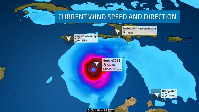
Current Wind Speed and Gusts
Caribbean, Bahamas Impacts
Impacts are beginning to wane in Hispañola (including Haiti), but mudslides may continue for days thanks to rain-soaked ground.
(NEWS: Latest Caribbean Impacts)
Eastern Cuba conditions will slowly improve Wednesday, though some rainbands may trigger additional flash flooding.
Meanwhile, conditions will steadily worsen in the Bahamas.
Here is the approximate timing of the worst wind and surge impacts, coinciding with the nearest passage of the eyewall of Matthew in the Bahamas:
- Southeast & central Bahamas: Through Thursday morning
- Northwest Bahamas (including Nassau & Freeport): Late Wednesday night through Friday morning
(MORE: Facts/Myths About the Hurricane Cones of Uncertainty)

Projected Path and Intensity
Over a foot of rainfall from Matthew will trigger life-threatening flash floods and mudslides. Here are the latest storm-total rainfall amounts from the National Hurricane Center:
- Southern Haiti, southwest Dominican Republic: 15 to 25 inches, locally up to 40 inches
- Northwestern Haiti, eastern Cuba: 8 to 12 inches, locally up to 20 inches
- The Bahamas: 8 to 12 inches, locally up to 15 inches
- Turks and Caicos: 2 to 5 inches, locally up to 8 inches
- Northeast Haiti, northern Dominican Republic: 1 to 3 inches, locally up to 5 inches
(MORE: Haiti’s Deadly Hurricane History)
On the current forecast track, here are the latest storm surge forecasts from the NHC, above normal tide levels at high tide:
- The Bahamas: 10 to 15 feet
- North coast of Cuba east of Camaguey: 4 to 6 feet
It’s worth noting this forecast for the Bahamas is on the order of storm surge witnessed during Hurricane Joaquin almost exactly one year ago, only for, potentially, the entire chain, rather than just the central and southeast Bahamas.
(FLASHBACK: Hurricane Joaquin 2015)
Battering waves will ride atop the storm surge, and coastal flooding from large waves may begin well in advance and ahead of Matthew’s center.
This storm surge will also limit rainfall runoff in some places, aggravating flooding, especially in coastal locations where swollen rivers cannot drain.
Hurricane-force winds, with peak timing as outlined above, will lead to widespread structural damage, particularly to poorly-built structures, numerous downed trees and widespread power outages. Due to wet ground, trees will be even more susceptible to being toppled.
U.S. Threat
Matthew’s center will make a close-enough pass to a large swath of eastern Florida to bring hurricane-force conditions at least to the Atlantic coast. If the center moves close enough, at least the western eyewall could bring destructive winds to at least Category 3 intensity.
The reason for this is stronger high pressure aloft persisting over the western Atlantic and East Coast of the U.S., helping to trap Matthew close to the coast.
(NEWS: Southeast U.S. on Alert)

Upper-level steering factors in play for Matthew later this week.
(MORE: Hurricane Central | Interactive Storm Tracker Map)
Here is the approximate timing of the worst wind and surge impacts, coinciding with the nearest passage of the eyewall of Matthew. (Note that Matthew’s eye may never make landfall, but its eyewall, containing the hurricane’s strongest winds, may do so.)
- Southeast Florida: Thursday through early Friday
- Northeastern Florida/Georgia coast: Friday through early Saturday
- South Carolina: Saturday and Saturday night

Hurricane Force Wind Probabilities
Chance of sustained winds reaching or exceeding 74 mph.
Small, subtle changes in the path of the eyewall, sometimes not resolvable until hours before the passage, will make a large difference on wind impact.
(MORE: When Hurricanes Parallel the Coast Instead of Making Landfall)
This uncertainty was best summarized by the 11 a.m. Wednesday forecast from the National Hurricane Center:
When a hurricane is forecast to take a track roughly parallel to a coastline, as Matthew is forecast to do from Florida through South Carolina, it becomes very difficult to specify impacts at any one location. For example, only a small deviation of the track to the left of the NHC forecast could bring the core of a major hurricane onshore within the hurricane warning area in Florida. However, a small deviation to the right could keep the hurricane-force winds offshore.
In addition to the wind damage potential, significant storm surge flooding is possible along the Florida East coast north of West Palm Beach building Thursday, continuing into Friday. The storm surge flood potential will spread up the coasts of Georgia, South Carolina and southern North Carolina through Saturday. Battering waves riding atop the surge will lead to beach erosion.
(MAP: NHC Prototype Storm Surge Watch/Warning)
Again, depending on the exact path of Matthew, rainfall flooding may be a threat, as well, along parts of the Southeast coast into the weekend.
(FORECAST: Detailed U.S. Impact Outlook)
You may have noticed the forecast track has changed for areas from North Carolina northward, as it now appears increasingly likely Matthew will not get “picked up” by a southward dip in the jet stream forecast to push into the Northeast U.S. this weekend.
Instead, Matthew may drop southeast away from the coastal Carolinas later Sunday. It’s possible Matthew could then meander off the Southeast coast or northeast of the northwest Bahamas into early next week, but details on where it may eventually go from there are uncertain at this time.
So, for now, the threat to the Northeast U.S. from Matthew appears to have diminished substantially, but we can’t rule out a Matthew track later nextweek near the Northeast U.S.
All interests along the Southeast U.S. East Coast should be rushing preparations to completion.
Check back with us frequently at weather.com for any important forecast updates.
Storm Reports, Recap
George F.L. Charles Airport on St. Lucia picked up 9.21 inches of rain Wednesday. On the south side of the island, Hewanorra Int’l Airport picked up 13.19 inches of rain in just 12 hours from 8 p.m. Wednesday through 8 a.m. Thursday, according to the Antigua Met Service.
Flooding during Tropical Storm Matthew in St. Lucia https://t.co/TEjL3V76zN via @YouTube
— 268Weather (@268Weather) September 29, 2016
A wind gust to 89 mph was reported in St. Pierre, Martinique, Wednesday evening. Some stations are elevated at 50 to 100 feet. Sustained winds of 39 mph were reported on the island of Barbados.
http://twitter.com/rairizarry/status/781194458297696257?ref_src=twsrc%5Etfw
Matthew strengthened to a rare Category 5 late Friday evening, becoming the first Category 5 Atlantic basin hurricane since Hurricane Felix in early September 2007.
(MORE: Category 5 Hurricanes Prior to Matthew)
Hurricane Matthew became the fifth hurricane of the 2016 Atlantic hurricane season early Thursday afternoon.
According to Colorado State University tropical scientist Dr. Phil Klotzbach, Matthew became the lowest latitude Category 5 hurricane in the Atlantic on record (beating the old record set by Ivan in 2004).
Some outer rainbands triggered flash flooding in Jamaica Sunday, hundreds of miles away from the center of Matthew.
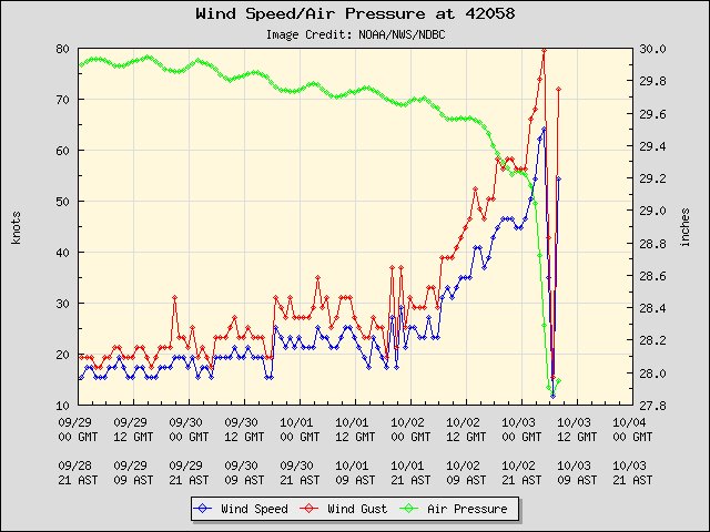
Interestingly Sunday night, a fortunately-placed NOAA buoy sampled Matthew’s eye, providing valuable information for meteorologists.
Hurricane Matthew’s eye first came ashore in the Greater Antilles in the western Tiburon Peninsula of Haiti near the town of Les Anglais around 7 a.m. EDT Tuesday morning, according to the National Hurricane Center.
Huracán Matthew entra a Cuba por el pueblito de Jauco en Punta de Maisí, Guantánamo, con vientos de 140 mph. pic.twitter.com/LP6frrs39Y
— CycloforumsPR (@CycloforumsPR) October 4, 2016
Matthew was the first Category 4 Haiti landfall since Hurricane Cleo in 1964, and only the fourth such intensity or stronger hurricane to track within 65 nautical miles of southern Haiti’s Tiburon Peninsula since the 1960s, according to NOAA’s Best Tracks Database.
Hurricane Matthew made a second landfall near Juaco, Cuba, around 8 p.m. EDT Tuesday evening. October 4. An unconfirmed wind gusts to 155 mph was reported in the town of Baracoa, Cuba, in Matthew’s eyewall.
Huracán Matthew entra a Cuba por el pueblito de Jauco en Punta de Maisí, Guantánamo, con vientos de 140 mph. pic.twitter.com/LP6frrs39Y
— CycloforumsPR (@CycloforumsPR) October 4, 2016
Radar from Guantanamo Bay Wednesday morning indicated Matthew’s eyewall had a sizable hole in its western side after passing over Cuba Tuesday night.


