Massive Volcanic Eruption Spews Ash 20,000 Feet into the Air (Videos)
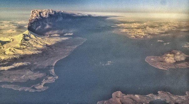
(N.Morgan) The most active volcano in Alaska, the Pavlof Volcano has erupted sending ash flying as high as 20,000 feet into the air. The flying ash prompted authorities to issue flight warnings.
Located on the Aleutian Islands, began, the Pavlof Volcano began “erupting abruptly” Sunday afternoon, according to the Alaska Volcano Observatory.
As of early Monday morning, residents were still under a Volcano warning and aviation is currently still under Code Red- it’s highest threat level.
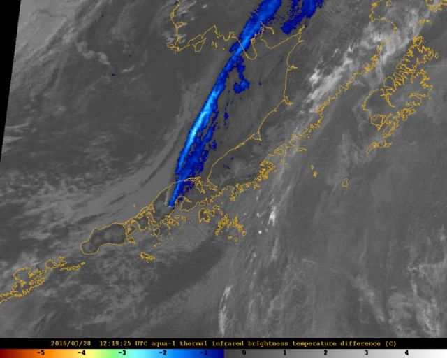
According to the volcano observatory, the ash was reportedly moving north after the eruption.

Ash cloud from #Pavlof visible on 6:45 p.m. (AKDT) infrared satellite image streaming northward.pic.twitter.com/mlXzZT0kBU
— Brian Brettschneider (@Climatologist49) March 28, 2016
Seismic activity was also reported after the quake. The last time Pavlof volcano was active, it erupted in November 2014.

Satellite image showing strong ash signal (blue) extending more than 500 km (300 mi), north-northeast from Pavlof, 4:19 am AKDT (12:19 UTC), March 28, 2016.
Current reports courtesy of The Alaska Volcano Observatory
AVO/USGS Volcanic Activity Notice
Volcano: Pavlof (VNUM #312030)
Current Volcano Alert Level: WARNING
Previous Volcano Alert Level: NORMAL
Current Aviation Color Code: RED
Previous Aviation Color Code: GREEN
Issued: Sunday, March 27, 2016, 5:12 PM AKDT (20160328/0112Z)
Source: Alaska Volcano Observatory
Notice Number: 2016/A2
Location: N 55 deg 25 min W 161 deg 53 min
Elevation: 8261 ft (2518 m)
Area: Alaska Peninsula Alaska
Volcanic Activity Summary: Pavlof Volcano began erupting abruptly this afternoon, sending an ash cloud to 20,000 ft ASL as reported by a pilot. As of 4:18 pm AKDT (00:18 UTC), ash was reportedly moving northward from the volcano. Seismicity began to increase from background levels at about 3:53 pm (23:53 UTC) with quick onset of continuous tremor, which remains at high levels. AVO is raising the Aviation Color Code to RED and the Volcano Alert Level to WARNING.
The view from the FAA webcamera is obscured by clouds this afternoon, and there are no current satellite images. AVO is monitoring the situation closely and issue further updates at the situation develops.
Recent Observations:
[Volcanic cloud height] 20,000 ft ASL
[Other volcanic cloud information] Unknown
Remarks: Pavlof Volcano is a snow- and ice-covered stratovolcano located on the southwestern end of the Alaska Peninsula about 953 km (592 mi) southwest of Anchorage.
The volcano is about 7 km (4.4 mi) in diameter and has active vents on the north and east sides close to the summit. With over 40 historic eruptions, it is one of the most consistently active volcanoes in the Aleutian arc.
Eruptive activity is generally characterized by sporadic Strombolian lava fountaining continuing for a several-month period.
Ash plumes as high as 49,000 ft ASL have been generated by past eruptions of Pavlof, and during the 2013 eruption, ash plumes as high as 27,000 feet above sea level extending as much as 500 km (310 mi) beyond the volcano were generated.
The nearest community, Cold Bay, is located 60 km (37 miles) to the southwest of Pavlof.
References:
Contacts: Michelle Coombs, Scientist-in-Charge, USGS
http://www.avo.alaska.edu/activity/Pavlof.php
http://www.youtube.com/watch?v=9C2tO9E7fQ4

