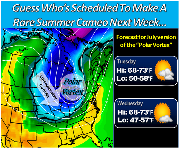
The Polar Vortex Is Back… In The Middle Of July
ZeroHedge.com
While every single economist and “straight to CNBC” pundit was quick to blast the atrocious economic performance in Q1 as solely due to the “harsh weather”, what has emerged in various retail earnings reports so far in Q2 is that, drumroll, they lied. In fact, as one after another “stunned” retailer admits, the depressed spending observed during Q1 continued, if not deteriorated even further, in the second quarter. Which means only one thing, the same thing we said back in January: as a result of Obamacare, the declining credit impulse resulting from the Fed’s tapering, and a ongoing contraction in global trade as the world slides back into recession, the US economy is on the verge of stalling and may well enter into a tailspin if one or more exogenous events take place in a centrally-planned world that is priced to perfection.
To be sure, one of the potential scapegoats we highlighted previously was the replacement of the polar vortex with what we dubbed the “solar vortex“, ala El Nino, which as we further reported, has already been blamed in advance by the Bank of Japan for a spending collapse set to take place in the second half of 2014, the year when the Japanese economy now almost certainly re-enters recession.
But just to make sure that the abysmal Q1 GDP which has now spilled over into Q2 and will likely see the US economy growing in the mid-2% range, has a sufficiently broad “excuse” in the third quarter of the year, here comes – in the middle of July – the polar vortex 2.0. As WaPo reports, “However you choose to refer to the looming weather pattern, unseasonably chilly air is headed for parts of the northern and northeastern U.S at the height of summer early next week.”
Bearing a haunting resemblance to January’s brutally cold weather pattern, a deep pool of cool air from the Gulf of Alaska will plunge into the Great Lakes early next week and then ooze towards the East Coast.
The atmospheric impact will not be nearly as dramatic, but still temperatures are forecast to be roughly 10 to as much as 30 degrees below average.
This means that in parts of the Great Lakes and Upper Midwest getting dealt the chilliest air, highs in this region could well get stuck in the 50s and 60s – especially where there is considerable cloud cover.
And focusing on next week specifically, “Wednesday morning’s lows may drop into the 40s over a large part of the central U.S.”
Highs may struggle to reach 80 in D.C. next Tuesday and Wednesday with widespread lows in the 50s (even 40s in the mountains).
More from WaPo:
What’s behind this unusual winter weather pattern primed for the dog days of summer? A lot of it is simply chance (randomness), but Weather Underground’s meteorologist Jeff Masters says Japan’s typhoon Neoguri is playing a role in the pattern’s evolving configuration:
….the large and powerful nature of this storm has set in motion a chain-reaction set of events that will dramatically alter the path of the jet stream and affect weather patterns across the entire Northern Hemisphere next week. Neoguri will cause an acceleration of the North Pacific jet stream, causing a large amount of warm, moist tropical air to push over the North Pacific. This will amplify a trough low pressure over Alaska, causing a ripple effect in the jet stream over western North America, where a strong ridge of high pressure will develop, and over the Midwestern U.S., where a strong trough of low pressure will form.
What amazes me most about the pattern is not so much the forecast temperatures, but the uncanny similarities in the weather patterns over North America seen in both the heart of winter and heart of summer. All of the same features (refer to the map at the top of this post) apparent in January are on the map in mid-July: low pressure over the Aleutians (blue shading), a large hot ridge (yellow and red shading) over the western U.S., the huge cold low or vortex over the Great Lakes (blue and green shading), and then the ridge over northeast Canada (yellow and red shading).
It’s not at all clear what this means or what, if anything, it portends. Weather patterns cycling through a certain circulation regime can repeat (and we’ve seen this pattern multiple times since November-December), but with El Nino forecast to develop, the global configuration of weather systems is likely to change.
So the question is: just how profound of an adverse impact on Q3 GDP (because remember: weather anomalies are never additive to GDP; only wars can do that in a Keynesian world) will the second, summertime coming of polar vortex have on the US economy? Judging by the laughable farce that the economic profession has devolved to, desperately seeking to “explain away” any deviation from a priced to perfection growth rate, if only that of the Fed’s balance sheet, not to mention why its forecasts are always wrong we are likely to find out very soon.


