BOMBOGENESIS: According to the Mainstream Media
Bombogenesis: What Happens When Low Pressure Becomes a Weather ‘Bomb’
By Linda Lam
The Weather Channel
At a Glance
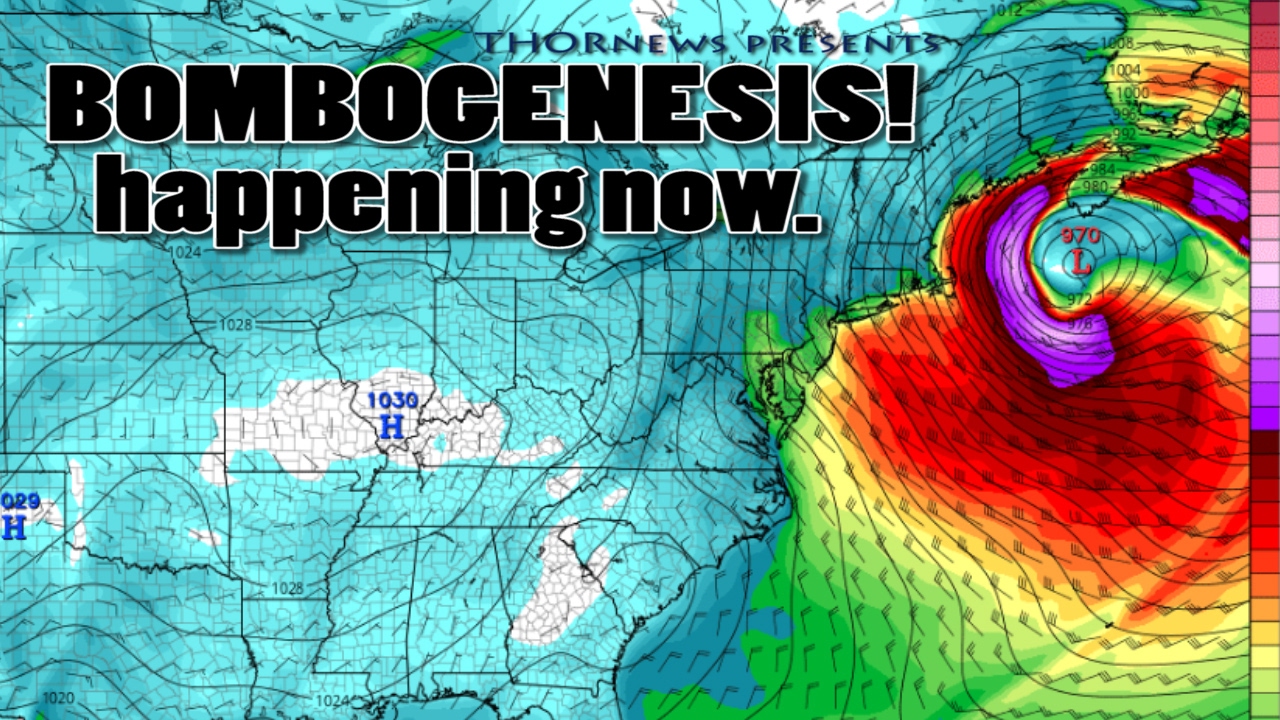
- Bombogenesis refers to a rapidly intensifying area of low pressure.
- To be classified as a weather bomb, the central pressure of a low pressure system must drop at least 24 millibars within 24 hours.
Bombogenesis is an ominous sounding term frequently used in the winter to describe powerful low pressure systems that intensify rapidly.
The process of bombogenesis begins as cyclogenesis, meaning the development or strengthening of an area of low pressure or trough.
To be classified as a weather bomb, or having undergone bombogenesis or “bombing-out”, the central pressure of a low pressure system must drop at least 24 millibars within 24 hours.

What Is Bombogenesis?
Bombogenesis results when there is a large temperature gradient, usually between a cold continental air mass and warm sea-surface temperatures. However, it can also be the product of a cold polar air mass and much warmer air from the south, say, over the Plains states.
Over that temperature contrast, a powerful, intensifying jet-stream disturbance triggers air to rise and kicking off the bombogenesis process.
This happens most often from October through March, but can happen any time of year.
Frequently, Nor’easters are weather bombs due to cold air surging southward from Canada combined with the warm ocean waters of the Gulf Stream.
So what happens when a weather bomb strengthens?
Winds increase dramatically and precipitation, including snowfall, can become intense. Blizzard conditions can occur, sometimes, accompanied by lightning as the system is bombing out.
A Few Notable Examples

Recently, Winter Storm Mars underwent bombogenesis in February 2016. The central pressure of this low pressure system dropped from 1004 millibars at 7 a.m. EST Sunday, Feb. 7 to 979 millibars by 1 a.m. EST Monday, Feb. 8, or 25 millibars in only 18 hours. Blizzard conditions were verified in multiple locations on Cape Cod and a wind gust of 65 mph was measured on Nantucket Island.
In 2015, Winter Storm Iola exhibited bombogenesis when the pressure dropped from 1009 millibars to 980 millibars from 7 p.m. Jan. 23 through 4 p.m. Jan. 24 – a drop of 29 millibars in 21 hours. Strong winds from Iola caused coastal flooding to some locations in Massachusetts.
This also happened in February 2013, when Winter Storm Nemo dropped 29 millibars within a span of 24 hours (specifically, a barometric pressure of 1000 millibars was recorded at 4 a.m. on Feb. 8, and it dropped to to 971 millibars at 4 a.m. on Feb. 9). Winter Storm Nemo ultimately “bottomed out” with a minimum barometric pressure reading of 968 millibars at 4 p.m. on Feb. 9. This powerful low pressure system resulted in a wind gust of 83 mph near Cuttyhunk, Massachusetts and thundersnow was reported on Long Island.
Mars, Iola and Nemo all brought snow to areas of the Northeast, but even though weather bombs typically are found during the winter with a marine influence, this is not always the case.
An example of bombogenesis over land was the “Octobomb” that impacted portions of the Plains and Midwest Oct. 25-27, 2010. All-time record low barometric pressure readings were set by this system in Minnesota and Wisconsin.
Tropical cyclones can also undergo rapid intensification, which is a particularly unnerving development especially when it occurs near landfall. An example of a tropical cyclone undergoing bombogenesis is Hurricane Charley in 2004.
___
http://weather.com/science/weather-explainers/news/what-is-bombogenesis-weather-bomb