Map: Large Wildfires In Montana (updated)
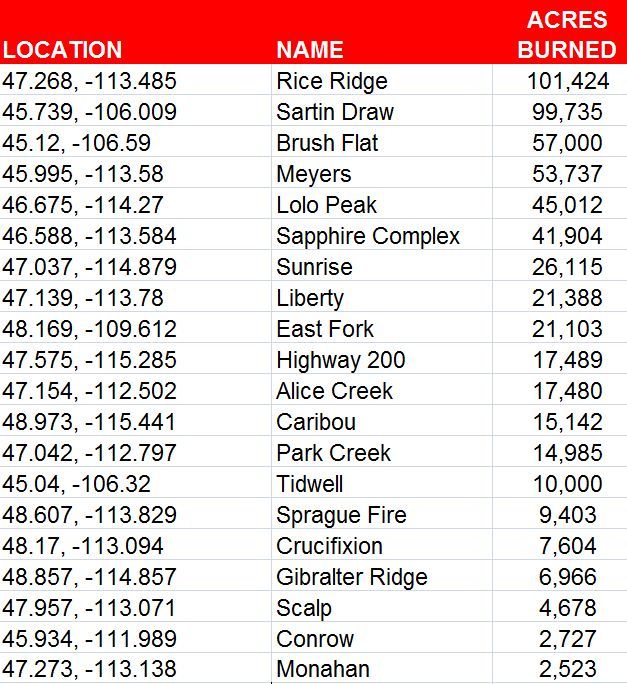
(GREAT FALLS) Here is a list and map of the 20 largest wildfires currently burning in Montana.
The fires represented on the map below are all actively burning and have scorched at least 1,000 acres. There are several dozen smaller fires currently burning in Montana that are not included in this map.
Recent fires that have been completely extinguished, are not actively burning, and/or do not pose a threat to lives or homes, are not included. Those fires are no longer being updated on Inciweb, a website which provides information and updates on wildfires across the state. One example is the Lodgepole Complex Fire, which burned more than 270,000 acres in central/eastern Montana several weeks ago.
- Map: Large Wildfires In Montana
- Bullock declares state of disaster in Montana due to wildfires
- Wildland firefighting terms: what do they mean?
- Sperry Chalet at Glacier National Park destroyed by fire (video)
- Lodgepole Fire Complex 80% contained; FEMA funds approved
- Montana National Guard arrives to fight Meyers Fire
- Bullock declares fire emergency in Montana
Click here for recent FireWatch articles and videos.
All data below is from Inciweb and Interagency Dispatch Centers as of 3 p.m. on Monday, September 4, 2017.
Click on a fire icon below to see the name and current acreage of each fire.