
Iran and Iraq quake kills more than 340
Iran-Iraq earthquake: Deadly tremor hits border region
A 7.3-magnitude earthquake has shaken the northern border region between Iran and Iraq, killing at least 343 people and injuring thousands more.
One Iranian aid agency said 70,000 people needed shelter after the quake, one of the largest this year.
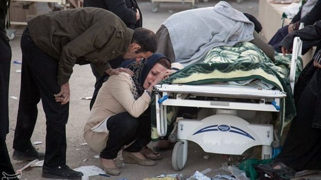
The majority of those who died were in Iran’s western Kermanshah province. Nearly 4,000 were said to be injured.
Seven people died in Iraq, where people fled into the streets in the capital, Baghdad.
“I was sitting with my kids having dinner and suddenly the building was just dancing in the air,” a Baghdad mother-of-three, Majida Ameer, told Reuters news agency.
“I thought at first that it was a huge bomb. But then I heard everyone around me screaming: ‘Earthquake!'”
In the latest updates from Iran:
- State news agency Irna quoted an emergency official as saying 3,950 people were injured in Iran alone
- Other agencies said the number of injured could in fact be higher than 5,300
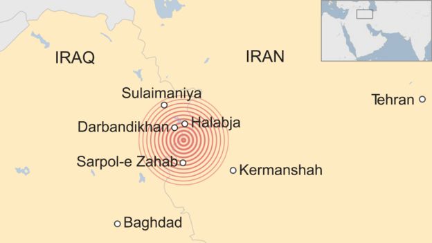
- Most of the victims were in the town of Sarpol-e Zahab, about 15km (10 miles) from the border, emergency services chief Pir Hossein Koolivand said
- The town’s main hospital was severely damaged, leaving it struggling to treat hundreds of wounded, state TV reported
- A woman and her baby were pulled alive from rubble in the town, Iranian media said.
Many homes in the predominantly Kurdish mountainous area are made of mud bricks. As a result, they are at risk of collapse during a significant earthquake like the one that struck on Sunday.
Rescue teams were being hampered by landslides, Mr Koolivand said.
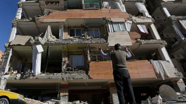 REUTERS/TASNIM NEWS AGENCY – A man looks at his damaged building in Kermanshah, Iran
About 1.8 million people live within 100km (60 miles) of the epicentre, the UN estimates.
On the Iraqi side, the most extensive damage was in the town of Darbandikhan in the Kurdistan Region.
“The situation there is very critical,” Kurdish Health Minister Rekawt Hama Rasheed told Reuters.
The Iraqi ministry of health said 321 people had been wounded in the Iraqi Kurdistan region.
The BBC’s Rami Ruhayem, in the regional capital Irbil, said shaking there had lasted for more than a minute.
“For a few seconds at first it was barely detectable, I wasn’t sure whether it was a minor tremor or just my imagination,” he said. “But soon enough it was unmistakable as the building started swaying from side to side.”
 REUTERS/TASNIM NEWS AGENCY – The death toll is expected to rise in Iran
The quake hit at 21:18 local time (18:18 GMT) about 30km southwest of Halabja, near the northeastern border with Iran, the US Geological Survey (USGS) said.
It occurred at a relatively shallow depth of 23.2 km, and tremors were felt in Turkey, Israel and Kuwait.
In 2003, a 6.6-magnitude quake destroyed the historic city of Bam in south-east Iran, killing 26,000 people.
Sunday’s quake is the deadliest to hit Iran since 2012. But it is only the sixth earthquake of magnitude-7.0 or more in 2017 – there were 16 last year and 19 the year before.

Why is Iran prone to earthquakes?
Analysis by Jonathan Amos, BBC Science Correspondent
Iran is one of those regions of the world that is all too familiar with quakes, and has experienced some very big tremors in the past.
In general terms, the big driver here is the clash between the Arabia and Eurasia tectonic plates. The former is pushing north by a couple centimetres a year.
In the south-east of the country, the Arabia plate is actually pushing under the Eurasia plate, but in the northwest these great slabs rub directly against each other. The Zagros mountains are a result of all this compression.
Early reports indicate the quake occurred on a thrust fault. This means the crust on one side of the break in the rocks is moved vertically up and over the other side – which fits exactly with this general picture.
Geological agencies now produce immediate bulletins on the likely expected casualties. This modelling work is based on factors such as the size of the quake, population density and what is known about local construction methods. It’s inexact work, but the first bulletins suggested this event could produce many hundreds of deaths and perhaps thousands of injured individuals.